Google Maps intros 3D helicopter view functionality
Forget travelling from A to B – go via scenic route C
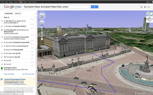
It looks like Google Earth and Street View are going to have to make way for Google’s latest visual navigation tool – helicopter view. Google’s 3D bird’s-eye view animation feature lets you visualise your journey from an aerial perspective – whether you’re driving or walking – “as if you were in a helicopter flying above the road.”
To preview your route, all you have to do is enter your starting point, destination and mode of transport, and hit the new 3D button that appears next to each route. The map will switch to Earth view where your journey is transformed into a visual navigational treat, revealing all the buildings, landmarks, mountains and other terrain you’ll encounter during your real-life journey.
You can pause your journey preview at any point and drag the map around to explore the surrounding area or landmarks. You can also access any geo-linked photos, videos or other online content along your route.
Even if you’re not planning on going anywhere, you can use Google’s new 3D simulator helicopter view to mock up pretend journeys while you daydream. Don’t all rush to Google Maps at once, though – Google hasn’t given everyone a ticket to its virtual flight just yet. Instead, only a select few have been able to hop on board. It’s unclear at this stage whether Google plans to roll its 3D preview feature out to the rest of its loyal Google Maps users, but in the meantime you could always knock yourself out with Google’s 2D driving simulator.
Also
Google Chrome coming to Android
 Stuff Staff